Geometry basic terms - learn geometry online
Geometry tools - what we need for this
Learn the basic geometry terms on this page.
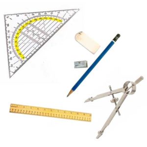
Before we really get started, we need some aids or tools for our work:
- Pencil (and a pencil sharpener)
- Eraser
- Ruler
- Set square / protractor
- Circle
- an arithmetic book with squared pages
Make sure that the pencil is always sharpened. Draw neatly in your notebook.
Even though we increasingly work digitally with a PC or tablet computer, it is important to learn geometry with compasses and rulers in the classic way on paper. Besides, it is much more fun to draw on paper!
Coordinate system
What is a coordinate system?
A coordinate system is the reference system for us to draw points and other geometric objects.
What is the coordinate system in times of GPS, mobile phones and navigation systems?
Without a coordinate system or a reference system, we would not be able to move and find targets in 2-dimensional or even 3-dimensional space. Only if the same reference point is available for everyone is the position of a point unambiguous.
In the real world in the time of navigation systems, mobile devices and geographical maps, the coordinate system is determined by the GPS coordinates and thus by the longitudes and latitudes of the globe.
A coordinate system for our work consists of:
- 2 axes, the horizontal x-axis (1) and the vertical y-axis (2) . Both axes are always perpendicular to each other!
- the origin or zero point (3), which is the intersection of the x-axis and the y-axis.
- a scale division on the x-axis (4) and the y-axis (5). This scale division is normally drawn in the exercise book every 2 boxes or at intervals of 1 cm!
Notice:
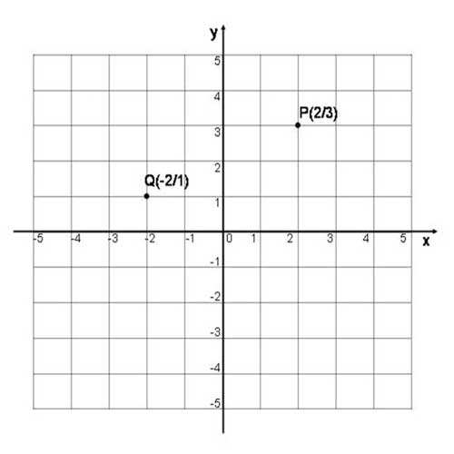
At the right end of the x-axis and at the upper end of the y-axis we draw a small arrow and label the axis with x and y respectively. Look at the coordinate system shown.
Points in the coodinate system / the coordinates of a point
Points indicate an exact location in a coordinate system, similar to a map.
Each point is indicated / marked with a capital letter!
In the coordinate system below these are the points P and Q.
Each point is uniquely determined by an x-coordinate and a y-coordinate.
P (2 | 3) means:
Go 2 steps on the x-axis in the positive direction (to the right) and then 3 steps perpendicular to this in the positive y-direction (upwards).
Q (-2 | 1) means:
Go 2 steps on the x-axis in negative direction (to the left) and then 1 step perpendicular to this in positive y-direction (upwards).
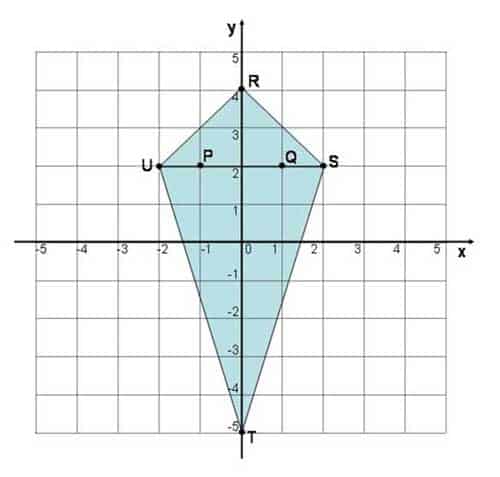
Example and first online exercise: Points in the coordinate system
Determine the coordinates of the following points
P, Q, R, S, T, U in the coordinate system.
Enter the x-coordinate and y-coordinate of all points in the fields!
Distance in the coordinate system
What is a distance in geometry?
A straight line between two points is called a distance.
The distance in the coordinate system is one of the basic geometry concepts that you need to know perfectly!
A distance is marked with a small letter. Let's take the distance s between the points P and Q as an example:
\( s=\overline{PQ} \)
We understand the term "route" better with a task as an example.
- We draw the points P (2 | 1) and Q (4 | 3) in a coordinate system.
- Now we connect the points P and Q.
We get the distance \( s=\overline{PQ} \)
Start the little video and you will see how the task is solved!
Notice:
We mark a route by writing the start and end points together (in capital letters) and putting a dash over the two letters!
The length of a line \( s=\overline{PQ} \) is also called the distance or spacing of the points P and Q.
It is designated \( |s|=|\overline{PQ}| \) .
Online Exercise Distance in the coordinate system
Look at the lines drawn and the points indicated on the right.
Drag the correct labels for the routes to the right place in the diagram!
You can maximise the task on the screen!
Straight line in the coordinate system
What is a straight line?
A straight line is a straight line without a starting and ending point. Straight lines are designated with small letters.
Although a straight line is infinitely long, we can only ever draw a straight line with a certain length because the space in the drawn coordinate system is limited.
Notice:
There is always only one straight line through two different points!
We want to get to know the straight line better and do a little exercise for this.
Exercise:
Draw the points P (-2 | -2) and Q (3 | 3) in the adjacent coordinate system and draw the line gwhich passes through both points.
Now determine the point of intersection S of the line g with the already drawn line h.
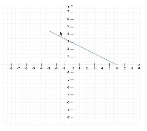
Below in the little video we show you the solution!
Online Exercise Straight Line in the Coordinate System
The exercise:
Given are the following straight lines in the picture next to it:
- g runs through points A and B.
- h runs through points C and D.
- l runs through points E and F.
- m runs through the points G and H.
Drag the names of the straight lines to the right place!
The exercise books for class 2
These exercise books do not have much to do with measuring angles or drawing angles. But they contain many interactive exercises from this WEB page!